
Callie and I made a trip up to the Sierra over Memorial Day weekend and she finally got her first backcountry experience. After spending the past 8 months hiking the San Gabriel Mountains, it was time for her to finally put that training to use on a proper backpacking trip. The weather was cool, the mountains were still snowy, the bugs were non-existant, and a great time was had.
Trip Details
Miles: 12 miles out and back
Elevation Gain/Loss: 3,000 feet
Day(s) Hiked: 5/27/12 > 5/28/12
Trailhead location
Dog Friendly: Yes
Red Tape: Overnight camping requires a permit from Inyo NF.

Trip Report
The trailhead to Pine Creek is tucked away in a canyon a few miles North of Bishop. There are no signs on the 395 to indicate that there is such a great hiking area down the road, so I had never been to this part of the Sierra before. It was only after scouring some maps that I noticed it and I immediately planned my Memorial Day trip to go check it out. An Eastern Sierra trailhead 5 hours away I haven’t been to? Not for long.
The trip was originally intended to be a 3 day/2 night trip to take advantage of the holiday weekend, but a nasty cold front moved through the area on Friday, dropping temps and a lot of snow on the mountains. Suddenly, the trip was brought into question but the forecast showed the weather clearing up on Sunday morning so we took the gamble and headed to Owens Valley to set ourselves up for an early Sunday start.Upon waking up on Sunday, we were greeted by clear blue skies and any worries about weather had vanished with the clouds. As we drove down Pine Creek road, the view of the canyon suddenly emerged, exposing our destination for the night. It was thrilling and a little intimidating to see the 3,000 feet of elevation gain right there in view, foreshadowing the certain pain in my shoulders that would accompany my first day of backpacking in 2 years. Unfortunately, Marissa was unable to join us on this trip, which meant that Callie and I were carrying extra heavy loads. The low temperature forecast of 20 degrees required carrying extra clothing which added even more weight to our heavy packs. Keep in mind that I carry over 10 pounds of camera equipment on these trips, so the weight can become an issue relatively easily.
We hit the trail around 9AM and began the steady ascent to Lower Pine Lake. The lower portion of the trail starts out by moving through a wooded area with Pines and Aspens intermixed with each other. Sections of the forest had large sections of downed Aspens, a sign of the extensive damage last winter’s wind storms did to the Eastern Sierra. After about a half mile, the trail begins to open up and become more exposed, which gives views of the landscape towering above.

The next couple miles switchback up a rough trail that traverses through a slope of shale. This is not the most inviting stretch of trail. Hikers have little shelter from the sun, and the route does not provide much scenery to counter its exposure and rough trail conditions. We were fortunate to be hiking this stretch in cool weather, as I suspect that the low elevation and exposure could make it an unpleasant stretch during a heat wave.The primary view during this stretch of trail is a closed down Tungsten Mine that is at the base of the canyon. This mine was in operation for almost the entire twentieth century and was shut down recently in the 1990′s.

Apparently the mine is still kept intact should the demand or prices of tungsten rise to justifty reopening it. Fortunately, the mine and all traces of civilization are out of view about 2 and a half miles into the hike.
As we ascended the trail we began to see our first signs of winter. A few shaded areas on northeastern slopes left snowfields at the base of cliffs. At first sight of these, Callie would sprint towards them and immediately begin dancing around in the snow. Normally I try to keep Callie focused on the hike, but I never cease to be amused by her unabashed love for the snow. I sat down on a rock with my pack to take the weight off and enjoyed taking a small break while firing off photos of the snow ritual.

A bit further up the trail there was a frozen stream, complete with a mini frozen waterfall – a testament to how cold it had been for the past couple of days. When I walked past this section of trail 24 hours later, the stream was trickling mildly with no ice in sight.

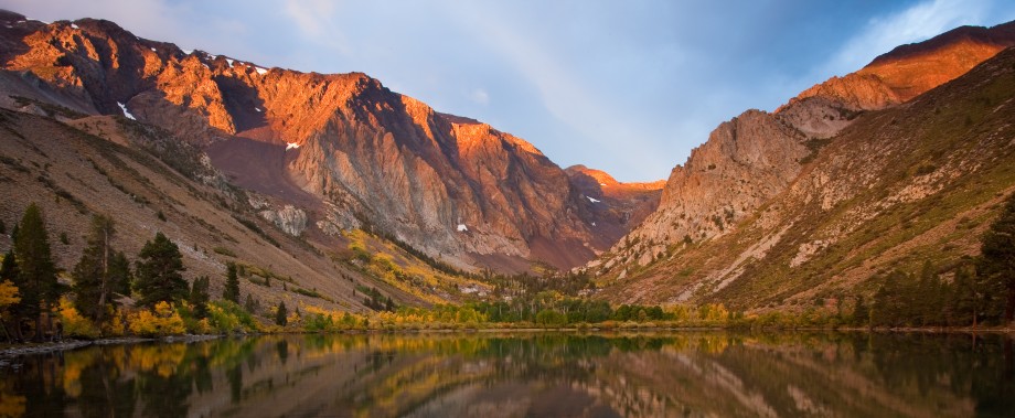
Around the 3 mile mark we got our first view of Pine Creek. Looking down from the trail, you see a series of cascading waterfalls as the river quickly descends a steep slope.

Looking back, we were greeted with a stunning window into Owens Valley. The air was clear and we could clearly see the White Mountains on the other side of the valley, and due to the recent storm they looked spectacular. I expect this view is extremely rare on a summer backpacking trip, and I felt fortunate to get to see it.

Around this point we entered the John Muir Wilderness, and this is where things began to get more interesting. After a few miles of slogging up the trail through the scree slope, you begin to walk through forested sections of trail that soon run parallel to Pine Creek. Civilization is long gone and trees and mountains fill your vision while the sound of running water dominates the soundscape.

A quick comment on the previous picture. See that white blob near the bottom? That is soap suds. When people jump into lakes with sunscreen still on, or rinse off soap in lakes or rivers, the suds will collect together and remain visible in the water for years to come. This is one of my biggest pet peeves about hikers, so please do your best to keep the water clean!
Right as I was getting used to hiking next to the river, we reached Pine Lake. Upon reaching this lake and seeing the expansive Sierra views behind it, I felt like I had finally arrived back at my favorite place on earth. Any anxiety I had for doing my first backcountry trip in 2 years, by myself, washed away in an instant. I sat down on the edge of the water and enjoyed a snack while soaking up the splendor.
After an enjoyable break, Callie and I continued along the trail on the Western side of Pine Lake to make our way to Upper Pine Lake. While crossing the West side of the lake, we came across an inlet alongside the trail where the water was reflecting a deep emerald color. It was gorgeous. I immediately pulled out the camera and began working to capture the landscape.

After I fired off a few shots, Callie decided she’d had enough and tromped into the water in the middle of my frame, sending off a series of ripples in the process. Note to self: Make sure Callie is tied up before attempting photos with pristine reflections.

The hike from Pine Lake to Upper Pine Lake is short and we were there within 20 minutes. While Upper Pine Lake is a perfectly relaxing lake that is a fine destination for a day hike, it didn’t seem particularly scenic so we moved right on past it after taking a quick photo to document the area.

After Upper Pine Lake the trail continues up the hill and it soon crosses a very wide stretch of Pine Creek. The crossing is about a hundred feet long and features a path of stones one can hop across. It was fun watching Callie decide how to negotiate the stretch. She would run through the river but then see me walking along the stones and decide that looked like more fun, eventually changing her mind by deciding that tromping through the water was a more fun approach. I had to grab her at one stretch as she began walking into deep water, oblivious to her pack and the fact that she was about to soak the contents inside of it.

Shortly after the river crossing we came across a trail junction. Pine Creek provides access to two different passes, Pine Creek Pass and Italy Pass. My original plan had been to explore the Granite Park area beneath Italy Pass, so we veered right towards Italy Pass. After a few hundred feet past the split, we reached Honeymoon Lake.
Honeymoon Lake sits at the bottom of Granite Park and thus provides great views of the prominent peaks in the area. It features a river stream that drops down a cliff and enters the lake on the Western Side and exits out on the Eastern Side which in my opinion made the lake especially scenic. The east side of the lake had a bunch of great campsites that were all unoccupied, and the decision to make camp here was easily reached. I began to set up camp while Callie enjoyed her afternoon nap.

This was one of the better campsites I’ve had the priviledge to camp at. Not only was it near the edge of the lake and the outlet stream, but it also had a great view of the ridge near the Pine Creek Pass to the Southwest.

While I was walking away from the lake to find somewhere to put my bear canister, I was given a surprise view of Upper Pine Lake with the White Mountains popping up in the distance.

The rest of the day was spent relaxing at camp and exploring possible photographic opportunities for tomorrow’s sunrise. The sunset light did not lend to great photography and I quickly retired to the tent with Callie to rest for the next day. I put on some music and watched the light slowly fade on the mountain range while I drifted to sleep.
The following morning I got up around 5:20am and began to prepare for sunrise. There was frost on the inside of the tent and all indicators were that it was cold as shit. Callie’s water bowl that I had left outside had turned into a nearly solid piece of ice. I did not take photographic evidence of this though, because I had a more specific goal in mind. I quickly set up in the outlet stream of the lake to shoot sunrise.
The alpenglow came quickly and I moved as fast as I could to make the proper adjustments to come away with the shot that I wanted. As I was setting up the focus for the photo, I accidentally triggered the shutter and fired off a shot. This unintentional shot was one of my favorite suprises of the trip and it reminds me to keep looking for different perspectives.

I’m also pretty fond of the shot that I initially intended to get 🙂

After the initial alpenglow had finished I went back to the camp and packed up a few things for a quick side trip. Callie and I went off to explore Granite Park. We slowly made our way around the lake which led to this different early morning view.

As we began to move past the lake and up the mountain, the landscape quickly changed to become predominantly rock and ice. I lost the trail, and at this point my motivation to explore Granite Park was gone. I had already gotten my sunrise shot, and the icy barren landscape didn’t seem that appealing to explore at the time.
I packed up our camp and we were off by 9am to hike back to our car the same way we came. On the way back, I noticed this one view that I hadn’t on the way in. The geology of the Sierra never ceases to amaze.

The hike down was quick and painless and we were back at the car by noon. Callie quickly passed out in the car and pretty much didn’t move for the next 5 hours. I’ve never seen her so tired. My job was done for now.


Great pictures and a fun trip report!
Epic report, thanks. You have inspired me to get back to the backcountry again. It has been 2 years for me as well (since I did Whitney). Honeymoon lake sounds like the perfect overniter.
What great shots! I stumbled across your site searching for info on trail conditions for a dog-friendly 4th of July backpacking trip in the Sierras (read: no super-challenging stream crossings or dangerously snowy passes). Keep the trip reports coming!
Very cool and such a cute dog! Thanks for the info, I’m doing a similar trip very soon.
Thanks for the fantastic trip report. Question: did you use any resource to check the snowpack remaining? We are planning on doing this route, but getting reports from the ranger station that there is still 4-5′ of snow. The ranger seemed uncertain though…and this seems unlikely since I think the snowfall this year was lighter than last. Thanks for any direction/suggestion you can provide!
It’s hard to get specific snowpack reports for trailheads. They are usually better at giving you a general idea of what the entire range is looking like. With that in mind, it has been a very dry year but it is still early enough that there is still snow dropping occasionally. There were a few storms in the past week that may have dropped a few inches of snow on the trail. I think that the current weather might block this weekend out but Memorial Day should be okay if next week is warm.
Thank you for the prompt reply! Yes, there was a storm last week apparently…we were planning on hiking in Tuesday. Guess we’ll find out when we get there. 🙂
Awesome blog, awesome dog. Your pics and writing style have convinced me that this is my next overnighter. Thanks!
Excellent photos! Thank you.
Wow!! This looks like a great hike with beautiful views! Thanks for sharing it.
Nice trip, did you mean Moon Lake?
Thanks. Nope, I did not mean Moon lake. Check out the map to see where Honeymoon Lake is.
Greetings! I found your blog looking for information on Honeymoon Lake. I think our blogs have very similar goals (http://trailsguide.wordpress.com/2013/06/27/burt-canyon-backpacking/) and our dogs would get along great! Pretty sure I have a picture of my dog in the exact same stance in the snow with her pack. Thanks for the info and I’m sure I’ll visit your blog again soon!
-Trails
Love the Website, and this looks great. Any suggestions for finding the trailhead from Highway 395?
Thanks,
-ken
It’s incredibly easy Ken. There is a google map link on the page here. You basically go about 5 miles north of Bishop, and then take Pine Creek Pass road all the way up.
Pingback: Hiking the North Fork of Big Pine | CaliTrails
I’m actually going to this place this coming Friday 7-11-14, is the there a safe parking place and also, how far is the parking from the trailhead, and is the parking area marked? Thanks in advance.
The parking is basically at the end of the road. You can’t miss it. The trailhead is right there. It’s as safe as any random trailhead in the National Forest.
Hi there, just got back from Honeymoon Lake, thanks for the info and for the blog, if it wasn’t for you, I wouldn’t have heard of this place! We had an awesome time! FYI, there was lots of other souls backpacking. There must have been 10+ cars parked at the lot, and we even hit the trail by 7am Friday. My thoughts suggested, that because of you, Honeymoon Lake got popular.
I will be following your blog and your footsteps, I hope you don’t mind.
Thanks again!
Hello Charlie,
I like your photograph of Pine Creek Tungsten Mine, and would like to use it as a comparison to a historic photograph of the mine in an unpublished report. Please contact me, as I want to ensure I am not disregarding any copyright.
Thank you,
Hi,
First off, my name is Brian. Second, I am not sure how to contact you. Please email me at brian@calitrails.com to discuss terms of use.
This is a fine post but you goofed when you decided not to go on to Granite Park. It is an awesome setting in all four seasons. I always try to spend at least 2 or 3 days there every time at get to that special spot.
Hi bob. Wife and I are thinking of going to Granite Park. But were concerned there wasn’t that mush ‘to do’ there, that it looked like a fairly narrow canyon, and not a lot of room for exploring. but you say you usually spend 2 – 3 days. We would probably want at least three. Is there enough exploring there to occupy this amount of time?
Hi Brian,
Great photos and informative narrative as usual. I often refer back to your map as I read your stories. A storm chased my wife and I off this trail last year. Now that I’ve seen your photos, we’ll be sure to return. I have photos of Sierra Nevada Bighorn Sheep up by the Tungsten Mine. I did a day hike to Horton Lake near there last week. There is also an upper and lower Honeymoon lake in Humphreys Basin off the Piute Creek Trail about 6 miles south of your Honeymoon Lake. Every year I hike a little slower and take better photos. You really know how to compose a shot.
Great post!! Did you see any other people on the trail? I’m curious if this would be a good overnight for some solitude!
I’ve hiked this trail a few times at this point. You’ll see some people, but not too many. Honeymoon Lake definitely gets some overnight visitors, but it’s less busy than most Eastern Sierra trailheads.
hello, I noticed your dog loves to nap on that blue pad. where did you buy it from?