
My brother and I dayhiked up Mount Whitney last weekend. It was our first time on the mountain and it surpassed expectations. The extreme mileage and elevation gain pays off with amazing views and a hair raising stretch of trail at 14,000 feet.
Trail Details
Mileage: 21 Miles
Elevation Gain/Loss: 6500 feet
Day(s) Hiked: 6/24/12
Trailhead Location
Dog Friendly: Partially (Dogs can hike up to Trail Crest)
Red Tape: All hikers must have a Whitney Zone permit from Inyo NF if they hike past Lone Pine Lake.

Trip Report
It’s 3AM on a Sunday morning, and my brother Dave and I are arriving at the Whitney Portal trailhead about to take on the biggest dayhike of our lives. As our friends and family are comfortably sleeping around sea level, we are assembling our gear under the illumination of headlamps at 9,000 feet elevation after a night of minimal sleep. Why would we do this to ourselves? Better yet, why do thousands of people enter a lottery every year for the opportunity to inflict this type of physical anguish upon themselves?
The answer is simple. Mount Whitney is the highest point in the continental US and it has become a rite of passage for many hikers. The peak rises above the already imposing Sierra crest to an impressive 14505 feet, and it has a trail all the way to the top. From Whitney Portal, the trail goes up 11 miles and the elevation gain ends up being about 6500 feet. Most people choose to camp somewhere along the trail in order to break up the hike into more manageable chunks while also giving themselves an opportunity to acclimate at high elevation.
The second point is very important to emphasize. At the summit of Mount Whitney, there is only about 60 percent of the oxygen in the air that you would find at sea level. This means that the higher up you get on the hike, the more difficult each step becomes. More importantly, the upper sections of the hike are high enough that altitude sickness, otherwise known as acute mountain sickness (AMS), can set in for people who are not properly acclimated. The severity of AMS varies greatly between a mild headache or cough to more serious symptoms that can end up becoming life threatening. Needless to say, it’s a very important factor to consider.
In our case, we were only in the area for the weekend, so we had a minimal amount of time to acclimate. We spent Friday night and the first half of Saturday around 10,000 feet in the Ancient Bristlecone Forest near Big Pine, and then Saturday night was spent in Lone Pine at only 4,000 feet. I felt comfortable with this plan as I’d climbed up Mount Shasta and Mount Langley with less acclimation time, and those are both difficult mountains over 14,000 feet high. It turns out that a second night of acclimation probably would have been beneficial in our case. More on that later.
As we exited the trailhead, I started up my heart rate monitor to track the amount of calories I would burn throughout the day. I wanted to see if I could tally up a 10,000 calorie hike, and this seemed like the perfect place to try. We headed up an empty trail shrouded in pitch black with only our headlamps to guide the way. It’s 3:15am now and I have 10,000 calories to go.
We quickly overtook a group of hikers and then had the trail all to ourselves. On both sides of the canyon, there are nearly vertical faces that rise up thousands of feet. Even in the middle of the night, the black outlines of the ridges could be seen against the backdrop of the celestial sky, appearing as goliaths towering above us from the heavens. Entering this vast wilderness alone in darkness, I was filled with adrenaline and excitement. It felt like we were on a real adventure that defied a simple dayhike in the mountains. This was going to be an experience that would stay with us for some time.
The initial excitement of the hike, matched with the cool morning air and relatively low elevation made this stretch very easy. We hauled up the mountain at a brisk pace, passing Lone Pine lake after about an hour. As we continued the climb above the lake, early predawn light could be seen over the White Mountains on the eastern horizon. The rainbow band of color contrasted brilliantly with the nearly black surroundings on the trail.

Over the next hour or so we continued the hike up and enjoyed the scenery as the surrounding landscape was slowly exposed by predawn light. The soft glow coming off the mountains matched with the silence and scope of the landscape created a very peaceful atmosphere. I was not carrying a tripod but did my best to capture the moment given the circumstances.

As we hiked above Mirror Lake, the morning alpenglow began hitting the major peaks in the area.

Since we were over 10,000 feet high, it felt as if we were basking in the light ourselves. Just a few weeks earlier, Dave had been asking me about the peculiar orange glow on the mountain in one of my photos, and now he was experiencing the phenomenon himself with this grand display.

As night turned to day, things began to feel normal again and our pace slowed down to a more reasonable clip. This was a good thing though, as overexertion at high altitude can easily lead to AMS. We tried to keep a moderate but deliberate pace. Above outpost camp, the trail changes to primarily granite, and thus it becomes more rocky and uneven. At certain points it is carved straight out of rock walls.

Approaching trail camp, the temperature began to drop significantly. Given the elevation and time of day, cold weather was expected. However, this was a particularly windy weekend in the Sierra and winds were gusting up to 40MPH at times. It felt very cold when the gale force winds picked up, and we quickly were wearing the majority of the layers we had brought.
While filtering water about a half mile from trail camp, a large group of hikers descended past us and after talking to one of them we learned that they had turned back at trail camp due to the high winds and cold temperatures. We were feeling pretty chilled ourselves and the news was disheartening. However, it turned out this was the coldest part of the hike and that group probably would have been fine if they started the hike an hour later so that the sun had warmed up the area a bit before they went through. When we eventually got to the summit, there was no wind at all.
At 7:15am we reached Trail Camp and I had burned 3500 calories already, which may or may not have covered the enormous portion of pizza I ate the night before. Trail camp itself was not what I expected. It’s essentially a rockfield next to a lake, at the base of the infamous 99 switchbacks. It’s also right on the trail. Forget any sense of solitude if you are planning on camping on this stretch.
Trail camp is the last permanent source of water on the trail, so make sure you gather enough water to get to the summit and back before you leave. Since we had filtered water just before arriving, we passed right on through and began tackling the dreaded switchbacks.
Starting at Trail Camp and up through the switchbacks, I began to notice numerous wag bags beside the trail. Since Mount Whitney is a heavily used area with limited soil, there is a regulation that all hikers take wag bags and carry out their waste instead of burying it which is the normal backcountry etiquette. Many hikers opt to leave their wag bags alongside the trail so that they can either pick it up on the return route, or leave it for someone else to deal with. I saw over a dozen of these in different locations and it definitely tarnished the wilderness experience. Please don’t Jersey the Sierra.

The switchback section of the trail is 2.2 miles long and it ascends 1750 feet to trail crest at 13777 feet. The view, while nice, never really changes. At this point, the “new mountain smell” has probably worn off and you might even be cursing the mountain. It’s a tough stretch of trail and Dave and I ascended it methodically without sharing many words with each other. We were on a mission.
About halfway up the cables (1.4 miles to be precise), there is a set of cables next to the trail. These cables are mainly setup because this section of trail often retains snow well into the summer, making it much more treacherous. Due to the low snow year, this section was already clear for us. This is extremely unusual for June, so keep that in mind if you are planning an early summer hike. Even without the snow, the cables were well appreciated by me because of a steep granite slope on the downhill side of the trail that would be a very bad place to fall.

Sections of the trail transformed into frozen streams and there were cool little frozen waterfalls next to the trail. Of course the streams were flowing a few hours later on the return hike.


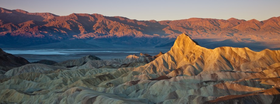
Our diligence paid off and we were up to Trail Crest by 9AM. The static landscape on the east side of the crest morphed into one of the most expansive views I had ever seen. From this ridge, hikers are given a view of the majority of Sequoia National Park’s backcountry. Having spent countless hours staring at topo maps of the region, it was amazing to see it right in front of me all at once. I felt elated.

From trail crest, the trail drops down a few hundred feet before ascending the last thousand feet to the summit. The trail here is carved through talus and is a little unstable. There are numerous sections with pretty steep drops offs to the western side of the trail, and given that the slope goes down a few thousand feet, it feels a bit precarious. If you have trouble with exposed trails, this stretch might be a problem for you. Dave and I loved it though. After the boring section of switchbacks, this dramatic stretch of trail re-ignited our enthusiasm and helped us with the final push to the summit.

The trail begins to pass by the Whitney Needles, and between each needle was a window looking East towards the Owens Valley and the lower sections of the hike.

After about a mile past the trail crest, the trail passes the needles and the exposure is mostly gone. The last stretch meanders through a rough slope of talus and finally reaches the top.

I reached the top of the mountain and I cheered Dave on as he made his final steps. He had started developing a slight headache and was laboring a bit during the last stretch, so we decided to make our visit to the summit a brief one.
We reached the summit at 11:05, 7 hours and 45 minutes and6100 calories into the hike. After months of anticipation and 11 miles of grueling uphill hiking, it felt fantastic to at last be on top of the mountain. The view from the summit is mainly looking East over Owen Valley. It feels like you can see the entire southern half of the valley from up there. The summit itself blocks a lot of the view looking west, but you get plenty of that view on the stretch between Trail Crest and the summit. We quickly posed for a picture to document our triumph, and after less than 15 minutes we were descending the mountain again.

The view South at the start of the descent offers a few interesting perspectives. For one, there is what appears to be an endless line of ridges looking towards the Golden Trout Wilderness.

There is also a great view of the switchbacks, providing an overhead angle of the relentless section of trail.

The entire stretch back to trail crest is ceaselessly beautiful.

At 1PM we were back at Trail Crest. I felt surprisingly great given the elevation and the fact that I had hiked nearly 15 steep miles. Unfortunately, Dave’s situation had turned for the worse and now his AMS was causing him great discomfort. I wasn’t worried about his safety, but with over 8 miles to go the rest of the hike was going to be a long slog. Dave did his best to remain upbeat but I could tell he was struggling to simply make it down the hill. He took a few long breaks on the switchbacks to re-compose himself, and I used the opportunity to capture the sky pilots that frequented the side of the trail.

It took nearly 2 hours to descend the switchbacks, which is about the same amount of time it took us to get up them – a sign of David’s worsening condition. There was nothing that I could do to help his situation other than get him down the mountain, so we slowly continued our descent and I tried my best to keep him engaged and his mind off the physical torment that he was experiencing.
As we passed the meadow by Bighorn Park, we got our last view of the upper area of the mountain. It was nice to see this beautiful meadow fully lit.

When we reached Lone Pine Lake, which signified that we had 3 miles left, David became instantly distraught. He thought we were almost at the car and the realization we still had a few miles to go seemed to devastate him for a moment. However, I have to give the guy credit for keeping his head up, feet moving, and attitude as positive as possible.
With a few miles left, my heart rate monitor ticked past 9999 and I had achieved the 10,000 calorie workout with some room to spare. I exclaimed my satisfaction to Dave, and he did his best to pretend to care as he labored down the hill.
We finished the last few miles at a snail’s pace. The section of trail we had hiked in the dark was now bathed in a soft indirect light. Dave managed to keep a smile on his face through it all, or most of it at least.

At 6:45pm we were finally back at the car. The hike had been 15 and a half hours long totaling 10755 calories burned. We flopped into our seats, cracked open some well deserved beers, and contemplated what had just transpired. Dave told me that he remembered the good parts of the hike more than the bad ones. For me, the memory I’ll keep is spending a day in the Sierra with my brother. The summit was an added bonus.


Excellent report. Makes me look forward to my August 14th ascent.
Great post, looks like an awesome day out. Would love to get over to that part of the world.
Thanks for the great chronicle of your ascent… Just got home from Whitney myself! We chose a 3-day ascent out of Horseshoe Meadow, and sad to say, we had to forego the summit (but making it to Trail Crest felt like an enormous accomplishment anyways!)
I trust anyone viewing this would have a VERY clear idea about the amazing experience you could have with this climb. BUT without a doubt… It’s not easy.
It was a bit sobering–we were greeted at our meeting place prior to the hike with newspaper headlines of a hiker’s body found the day before… and then… 4 days later, greeted at the END of our hike with a man holding vigil for 30 hours at Whitney Portal Trailhead, for any word on HIS missing friend. (We never saw him, but we were questioned midway-down by Rescue Rangers making a dash… uphill!)
So… if there is anything I would add to your account here, and repeatedly stress, it is: BE PREPARED! This climb is NOT to be taken lightly. It is beautiful, it is awesome… but it is indifferent. Respect both the mountain and your limits, and you will have an unforgettable life-changing experience ; ^ )
Nicely said Dean. Not to be morbid, but people do die on this mountain almost every year. Two scouts got hit by lightning in 2005 while I was on the mountain. I was stuck in a thunderstorm in ’02 and it was terrifying. But I’m climbing next Thurs (7/11) and it’ll be my 9th trip. The good always outweighs the bad and it is a truly special place. The key is to not get so caught up in trying to reach the summit that you forget to enjoy the journey.
Pingback: Whitney Portal to Lone Pine Lake | CaliTrails
looking for a partner for a aug 2014 to summit mt. whitney……..I did mt. elbert..mt. massive….mt yale all in colorado in 2013…………….I am 62 and a male……………b515490 @aol.com
live in ohio…………………………………anyone interested >>>????? one day hike
Hi Clarence,
Another place where you might a partner is WhitneyZone.com. Throw up a post there and see if you can find a partner. Good luck on the hike!
Are you still climbing day trip in Aug 2014?
I applied for a day permit for just me and Callie this year, we’ll see if we get one. If we do, we’ll only go to Trail Crest since that is the end of the line for where dogs can legally go. I want to take her up there before I hike the switchbacks again.
The whitney trail gets a lot of use, so I think that going solo is fine as long as you properly train for the hike and take a day or two to acclimate.
I have a September 12th day hike permit. I am 60 and going with a group of 4.
I applied for a permit in July. It’s my first time and I can’t find anyone to go with me so I will go solo. Hopefully I wouldn’t get lost in the morning.
The trail is very easy to follow at the beginning and there will most likely be other people on the trail nearby for most of the hike.
I did it by myself last year. Difficult to get lost. Always people on the trail.
Is the calories tracker accurate? Average Marathon is 2500-3000 calories. Does Whitney really burn that much, due to elevation gain?
It’s what my calorie tracker said.
Did you happen to count your total steps on the trip? I did this hike 4 years ago and plan on doing it again in May, but this time after a year of foot rehab. Major bunion surgeries on each foot.
Curious about step count because I really need to get my daily count up to make sure my feet are up to it.
Great journal tale of an amazing hike up a huge mountain!
Jeremy – I didn’t count. I would estimate over 100,000.
Pingback: Hiking the High Desert Loop | CaliTrails
I did the hike 10 days ago. The step count was 74116.
Who picks up the “wag bags”? So much toilet paper and general trash.
It is the responsibility of each individual to carry out their own wag bags. Obviously, this does not always happen. Rangers do the thankless job of hauling them out, but they have limited resources and things can stay out there for awhile.
Nice report. I hiked to the summit in 2012 and hiking it again tomorrow. 8-9-16. Your pictures bring back nice memories. Look forward to tomorrow.
Thanks for the beautiful and helpful trip report. Tomorrow (8/15/16), my wife and I are permitted to day hike Mt. Whitney for the first time. In the past week, we hiked Mammoth Mountain (11,053′), Mono Pass (12,077′), and White Mountain Peak (14,246′) to acclimatize. We feel prepared, but venturing into the unknown is always exciting. Your detailed account gives us a very good idea of what to expect.
Great post and fantastic photos! Brought back memories and I now want to go back and do it again – maybe mountaineers route. I Day Hiked Whitney on Monday, September 12th, 2016. I stayed overnight in Lone Pine and drove to the portal, arriving in time for a 4:00 am start. I Did hikes up to 26 miles and up to 10K feet to get in shape in weeks before. I “acclimated” by spending the week prior in Yosemite, Mammoth and Ansel Adams Wilderness, day hiking. (Still got a headache on top of Whitney). Took just under 12 hours up and down, and spent 25 minutes on summit. Fit bit said I burned 7,087 calories and took 62,266 steps with 860 floors. I weighed 185 lbs at 5′ 8″. I can see how someone bigger and taller could burn 10K calories. PS. I saw no wag bags along the trail in 2016 and fortunately, didn’t have to use mine. …