
After a 20 year hiatus, my dad and I finally got back into the Sierra to rekindle an old father and son tradition.
Trail Stats
Mileage: 24 miles
Day(s) Hiked: 9/7/12 > 9/10/12
Trailhead Location
Dog Friendly: Yes
Red Tape: Overnight camping requires a permit from Inyo NF
Trip Report
As a new father, I’ve been spending a lot of time lately thinking about the formative experiences of my childhood. Growing up in Northern California, I was fortunate to have access to the Sierra Nevada at an early age. My dad and I made frequent trips up to Yosemite as I grew up, and it was always something I looked forward to. My first backcountry experience was at the Sunrise High Sierra camp when I was about 10 years old. We bagged Cloud’s Rest as a dayhike, and the view of Yosemite Valley from up above cemented in my brain where life’s biggest treasures are found.

Top of half dome. 1993.
It goes without saying that I owe a lot of my love for the mountains to my father, and before I begin to pay it forward to my son, I wanted to get my dad into the Sierra backcountry to share this glorious place together another time. Despite experiencing so many great Yosemite trips together back in my childhood, it had been about 20 years since our last one. The trip up to the Sunrise camp had been the end of an era. Meanwhile, my passion for the outdoors has continued to develop and I try to get into the Sierra backcountry as much as possible. As I planned out the 2012 backpacking season, I decided that it was time to get pops back out there.
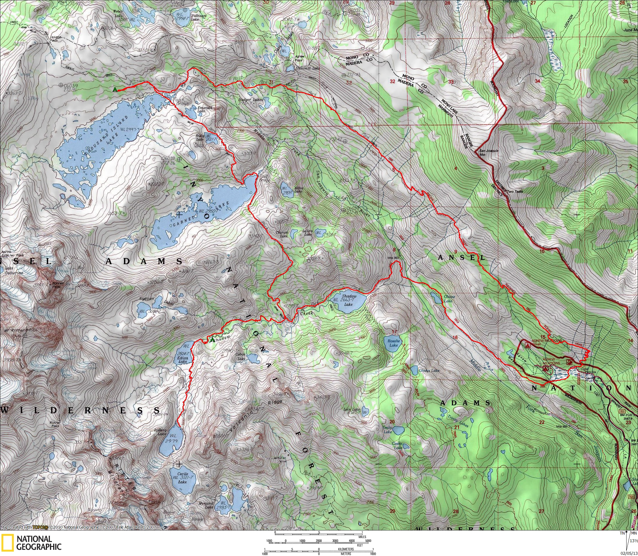
The location for the trip turned out to be an easy decision. Dad had never been to the Mammoth Lakes area, and the accessibility and sheer beauty of the mountains there made it a no brainer. I loaded up my trusty pack dog and headed up before dawn on a Friday morning in September, ready for 4 days in the mountains to cap off a great summer of backpacking. My dad was waiting for me in Mammoth when I arrived, having taken advantage of some precious acclimation time that I always seem to neglect. We grabbed some breakfast, organized our stuff, and hit the trailhead. The shuttle had stopped running only a couple of days previously, so we were lucky enough to be able to drive straight to Agnew Meadows.
The first day was up the river trail, past Shadow Lake, to Lake Ediza. It is a short hike without a ton of elevation gain, perfect for my dad’s old bones. Whenever one of us would act tired, Callie was there to cheer us on. This was her first backpacking trip with someone other than just me, and she relished in the opportunity to help herd the pack up the trail.

We ended up camping close to the creek below Lake Ediza, since the good campsites on the lake had already been taken. This is a very popular lake and the majority of the lake shore prohibits camping, so it can sometimes be a bit of a pain to find a site here unless you are willing to get off the beaten path a bit.
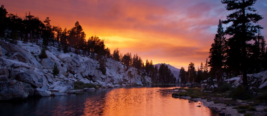
The following morning we awoke before sunrise and headed up to the lake to catch the alpenglow on the Minarets. Conditions did not disappoint, and soon enough the ridge was lit ablaze in a deep orange. The lake surface was nearly still and the beautiful scene reflected in almost perfect symmetry.

After the splendid sunrise, we retreated back to our camp, had some breakfast, and then packed up stuff for a dayhike up to Iceberg Lake. The trail up to Iceberg is a short stretch that ascends about 500 feet. There are great views of Ediza present for almost the entire stretch.


Iceberg Lake has a much different feel from Ediza. It is right at the tree line on a bench below the Minarets, and as a result it feels much more exposed and barren. On the opposite side of the lake, the Minarets tower well over a thousand feet above. What a breathtaking view!

We tried to linger and enjoy the spot, but our solitude was shortlived. After arriving to the lake and having it to ourselves, no more than 10 minutes later a flood of people began to arrive. Many people were backpackers that were passing through on their way to Cecile Lake. Some others were dayhikers like us who had reached their destination. There wasn’t enough room to spread out away from these people, so we decided to head back down to Ediza and take a break in the warm sun away from the crowds.

The original plan gave us the option to move up to Nydiver Lake to set up camp for night 2, or stay at Ediza if we weren’t feeling it. Dad was feeling tired, and I wasn’t sure that he would enjoy the offtrail travel anyways, so we decided to forego it and just relax at the lake for the rest of the day with our books. There are definitely many worse ways to spend a sunny afternoon.
I made my way back up to the lake for sunset and was rewarded with a great view. The clouds over the ridge line lit up as if there was a fire blazing on the other side of the mountains. The Eastern Sierra is usually best for sunrise but every once in awhile the conditions arise for a breathtaking sunset like this one.

The following morning I got up early and headed up the trail towards Iceberg Lake. I wanted to shoot another sunrise, and since I was content with my Lake Ediza shots it was time to try a new location. Upon reaching Iceberg, I was saddened to see that the winds had made the lake surface extremely choppy. With no wildflowers in bloom I struggled to find an interesting foreground, so I decided to try something different. I ascended the hill on the side of the lake opposite the minarets, and after ascending a few hundred feet I set up my tripod. The view that I ended up with was a different take than I had seen on Iceberg Lake before, and the Minarets were featured prominently, so the sunrise wasn’t a total bust.

Callie and I quickly retraced our steps and met up with my Dad who was relaxing at the campsite. Today’s goal was Thousand Island Lake, and we packed up our stuff and set out on the trail. In order to make things more pleasant for my dad, Callie and I were carrying the vast majority of the gear. This had Callie’s pack at close to 15 pounds, which is quite heavy for a 40 pound dog. Callie is no normal dog though, and you would never even know the pack weighed anything at all if you saw her on the trail.
She cooled her paws in every river that we passed,

and she curiously examined every furry creature that scampered around the trail.

It’s pretty amazing how packed with scenery this area is, because after only a couple of miles on the JMT we were at Garnet Lake, another one of my favorite places in the Sierra. We enjoyed some cheese and crackers along the lake shore and then continued along towards Thousand Island. Storm clouds built around us and it lightly drizzled as we circumnavigated the lake. Fortunately, the rain was intermittent and light and we didn’t even need to put on our raincoats.

The trail between Garnet and Thousand Island has a couple of lakes replete with typical Sierra beauty.

We arrived at Thousand Island and grabbed a site up on the hill about a hundred yards from the lake where we enjoyed a marvelous view on our final night.
The following morning I awoke to clouds over Banner Peak. It was the makings of a great sunrise so I sprang to action. The light never quite broke through the clouds though so it was tough to get the shot I was attempting.

Back at the camp, we made sure to get one last group portrait to commemorate the occasion.

It was time to go home, and we started heading down the high trail back to Agnew Meadows. The High Trail does not disappoint with views. As hiked along the Pacific Crest, Mount Ritter and the Minarets were seen popping up from behind the ridge line across the river valley.

The volcanic landscape of Mammoth Mountain dominated the view in front of us for the rest of the day, and all around us the foliage showed signs of the coming Fall. It was an incredible way to finish the hike. After all these years, we had pulled off our most memorable Sierra trip yet.


Your pictures are amazing, this looks like a beautiful hike.
Perhaps a three generation hike is in the cards someday!
Great photos again. How do you get such beautiful pix?
Thanks for the compliments!
Regarding my pictures, I carry around a lot of nice camera gear, and I’ve also been spending the past few years honing my landscape photography skills. What you see if the result of a lot of hard work!
Your hard work at photography has been worth it! Great pics.
I did a solo hike here last summer. The views are unforgettable. Thank you for sharing these great photos.
Doing this exact loop in reverse next month, can’t wait!
Awesome pictures. Do you have any suggestions on how to extend this to a 4 night/4.5 day trip? Looking to spend July 2-6th south of Yosemite in the Sierras, hiking anywhere from 8-12 mi/day. Any suggestions for another trip you’ve done further south for this amount of time would also be much appreciated! Looking for mainly for lakes and classic High Sierra scenery. Thanks!
You could go up to Nydiver Lake and check out that area. Garnet Lake is also worth spending some more time at. You won’t get 8-12 miles a day but the scenery is so nice that there’s no rush to get through it.
Another classic 4 night loop would be North – South Lake, or if you don’t want to deal with the car shuttle, North Lake – Piute Pass – Evolution Valley – Lamarck Col – North Lake.
Both look incredible, thanks for the suggestions. Is the North Lake loop on trail or partly XC?
North Lake to South Lake is all on trail, but you need a shuttle between the two lakes.
The alternative route that goes over Lamarck Col has some XC. It’s a well traveled route but there is some talus hopping.
Hi,
Two friends and I made this very trip last weekend, inspired by your web site. It was perfect! (Except I sadly had to leave my pups at home.) Thank you so much for this site, and for your wonderful trip reports. I am planning more trips based on your suggestions. And–we all live in the Altadena/Pasadena/Eagle Rock area, so maybe we’ll see you and Callie on the trail some day. We too love Cucamonga Peak and Baldy–although nothing compares to the Sierras!
Wow, this is amazing. Thank you for sharing. I wonder if you have any suggestions for me… Due to knee problems I cannot carry an overnight backpack. My easy go-to place is Desolation Wilderness since it’s gorgeous and there are plenty of day hikes. I’d like to spend a week in another gorgeous area with the type of scenery you have here on this page (which is even more dramatic than Desolation Wilderness). Do you happen to know of a good “base camp” for moderate day hikes? I think the big question is, is it possible to access a few dramatic hikes as moderate day hikes. I suspect you need to backpack to have access to this type of scenery? I’ll be doing this trip alone and might consider lodging (versus camping) so I don’t feel too alone. Any thoughts would be much appreciated. Happy trails!
I think Shadow Lake would be a great basecamp for this area. It’s an easy hike in, and a beautiful location on it’s own. From there, you have very easy hikes to Lake Ediza and Lake Garnett.
Right now there is no camping at Shadow Lake 😦 However, it is beautiful.
Doh. You are correct. My mistake. Thanks Sergio.
In that case, Garnett, Nydiver, or Ediza would be the most logical places to set up a base camp.
Hey!! What’s weird is that my real name is Ediza and my fiance and I were thinking about doing this hike to see “my” lake lol. Were you able to camp at Lake Ediza’ is there like a camp “site”? or do you just set up shop and make your own camp site??
This is backcountry wilderness, so you find your own campsite. Ediza has specific regulations. Basically, you need to find a spot on the west side of the lake.
Pingback: Thousand Island Lake, Ediza Lake, and Iceberg Lake Loop – Inyo NF, CA | Humbled by Nature
Superb. Great to see you are carrying on the traditions and sharing such beautiful experiences! Heading up to the Ediza/Thousand Islands area in a month. Your fantastic photography really fired the enthusiasm! Thanks!
What’s the elevation gain & loss for this trail? TIA!
I never took the time to figure it out. Probably around 4k feet up/down for the whole route.
My favorite spot. Fantastic photos! Taking my 2 dogs this year, and learned that muzzles are required on shuttle bus, and dog’s food must also be in a bear canister, so they must pack something else if I have to carry their food!
Yep, they gotta carry their load. Thanks for mentioning the muzzle rule with the shuttle.
Great trip and gorgeous photos – I am jealous!
Quick question – did you notice any decent campsites near Iceberg Lake? It looks like a great place to spend some time, but nobody seems to camp there. We’ll be in this areas in early September, and I hope we can find some good spots – Thanks!
There was an area where one could pitch a couple of tents. Not much else. It’s pretty barren by the time you get up there and there is not a lot of flat space off trail.
The pictures are stunning and your dog is such a trooper! What breed is Callie? I have a friend with a dog almost identical!
Well done
Callie is a pound puppy so we aren’t sure. We suspect she is some sort of chow mix.
I was planning on this exact trip in a few weeks, but winter conditions are still expected. Would you still recommend this route for an average backpacker? I’m assuming I’ll need crampons and an ice axe for higher elevations. What do you think?
Crampons and ice axe won’t be needed. Microspikes could be helpful. Have you ever hiked in snow? When are you planning on going? The shuttle to Red’s Meadow is not scheduled to start running until 6/18.
Thanks for the quick response! I’m heading out 6/6-6/8 and thinking of starting (Day 1) on the Rush Creek Trailhead to Gem and Waugh Lakes, (Day 2) Waugh to Thousand Island Lake, and (Day 3) Thousand Island to Clark Lakes to Rush Creek Trailhead. Elevations seem to go from 7,300′ to just over 10,000′. I do have an old set of microspikes, which I’d much rather carry. Highway 158 is supposed to be clear to the Rush Creek Trailhead.
I originally wanted to start from Agnew Meadows, but the rangers said I’d have to hike 5 miles into there from the lodge at Mammoth Mountain. I’ve done some snow hiking and snowshoeing years ago, but it’s been a while.
Thoughts?
I’d choose a different trip. Go further south, like Cottonwood Lakes or North Fork Big Pine. Go to this area when you can take advantage of the shuttle and snow is less of a concern.
Thanks for the input. Just grabbed a permit for the North Fork Big Pine trail. Saw you did this trail as well in 2014 with Callie. Unfortunately, my dog Sam will be staying home to keep the wife company while I’m out. Hoping to take them both out there later this year though.
And thanks for maintaining this blog. Great photography and trail info throughout. Much appreciated.
This is such a warm natural adventure with you & your dad; i sure enjoyed everything you wrote, and very nice photos too
And Callie is such a happy looking dog! Just beautiful
How lucky you are to be able to hike with your father as an adult! Thank you again for your stories and lovely photos..