

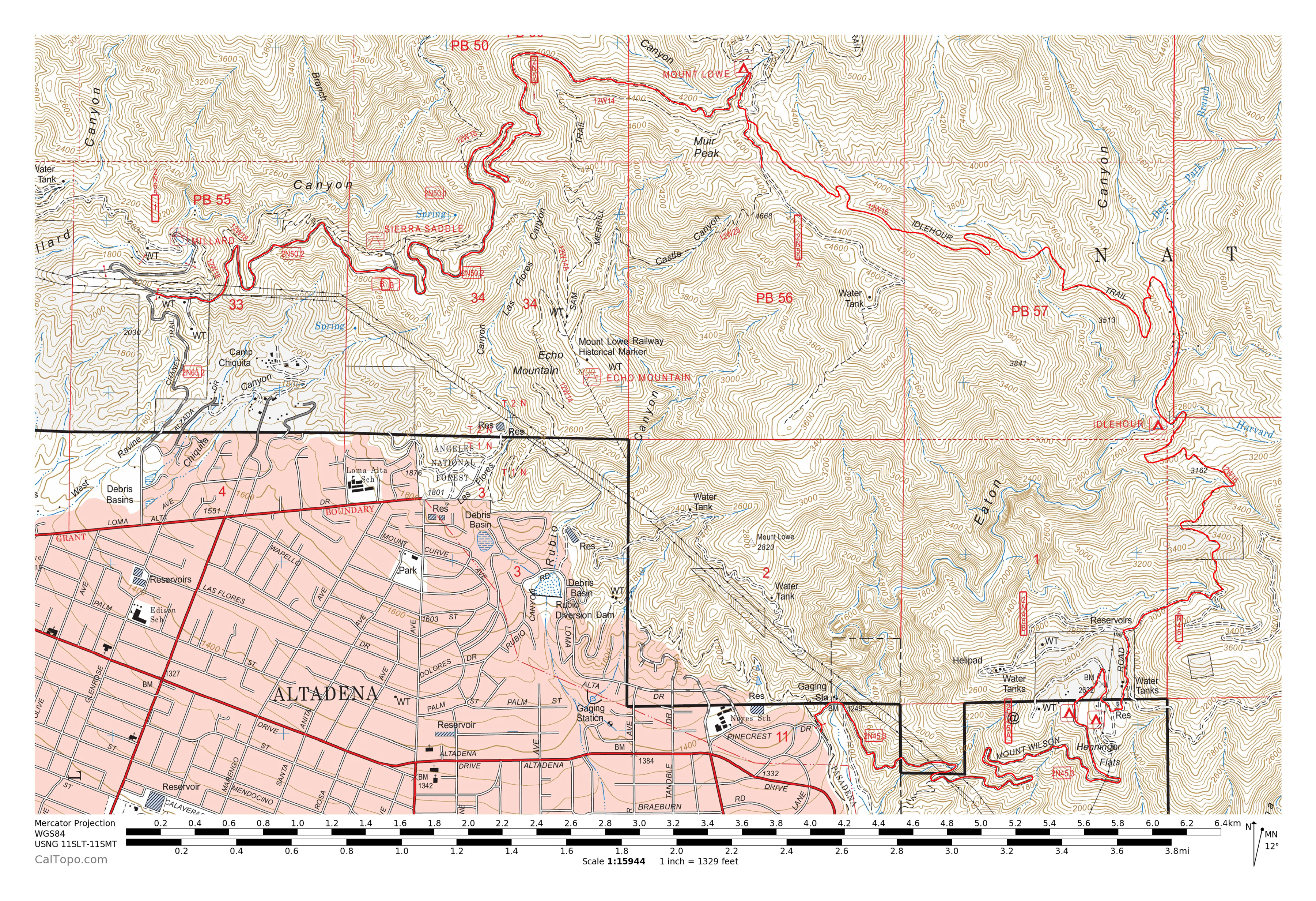
Tucked away in the foothills above Altadena, the Idlehour trail is a rarely traveled section of the San Gabriel Mountains that provides Angelenos an easy escape from the city’s crowds.
Trail Details
Mileage: 15.25 miles One Way (shuttle required)
Elevation Gain/Loss: 4100 feet Up / 3100 feet Down
Day(s) Hiked: 11/17/13
Trailhead Location
Dog Friendly: Yes
Trip Report
This trail holds a special place in my heart. It was the first big hike that Callie ever did, back when she was just seven months old. Even then, the long day of hiking didn’t really faze her and it was obvious that she was born to be a trail dog.
November is the ideal month to tackle this hike, with its cooler afternoons and sporadic fall colors along sections of the trail. So, we set out to tackle it once again this past weekend.
The Idlehour Trail is a 4.5 mile trail that goes through the upper reaches of Eaton Canyon as it traverses between the Mount Wilson Toll Road and the old Mount Lowe railway. There is no convenient loop to tackle the hike, and hiking the entire stretch of the trail, only to backtrack, would be a long monotonous hike no matter which way you tackled it. I suspect that this is why the trail gets little traffic. On our two visits we haven’t seen another person for the entire stretch, nor have we seen any of the discarded trash, tagged rocks, or carved up trees that distinguish Southern California trails.
Since this is a shuttle hike, it can be approached from either direction, but I think that starting out on the Mount Wilson Fire Road gives the day a nice flow. It’s also not ideal to not end a long hike at Pinecrest Gate since it is locked at sunset, which will force you to detour in the dark if you get stranded.
Pinecrest Gate also accesses the Eaton Canyon waterfall trail, so there are often a lot of hikers here. Neighborhood parking is easy, just make sure you pay attention to the signs. From the gate, the Mount Wilson Toll Road steadily ascends over 4000 feet up the mountain to its summit.
The Mount Wilson Toll Road was originally built in 1891 to provide easy foot and pack animal access up the mountain. Hikers were charged 25 cents, while horseback riders were charged 50 cents to access the road. The Toll Road was dubbed the New Mount Wilson Trail and it quickly became the most popular route up the mountain. Adjusting for inflation, that means that hikers were eagerly paying about 6 dollars per person to access the trail. That’s crazy! The toll road was in operation until 1936, when it closed due to construction of the Angeles Crest Highway. Now, it is a well maintained fire road that is popular among hikers, mountain bikers, and runners.

As the fire road ascends Mount Wilson, a wonderful view of Altadena opens up. We love living here and it’s always nice to get a view of the neighborhood from a local trail. There are a number of benches set up along the fire road perfect for taking in the view.

After about 3 miles and 1300 feet of elevation gain, the toll road reaches Henniger Flats. This is a developed campground with picnic tables, fire stoves, trash cans, outhouses, and water faucets. Last I heard, the water here still needs to be treated, in case you are thirsty on your arrival. I’d recommend researching ahead of time if you are planning on tanking up here.

Moving forward, the toll road veers into a canyon and provides some much appreciated shade. The road up to this point is completely sun exposed other than the brief respite at Henniger Flats.

Soon thereafter, there is a trail on the left side of the toll road as it bends a turn. There is no sign indicating that this is the Idlehour trail, but if you have a map handy it is pretty clear that it there are no other possibilities. This is it!

The hike takes on a very different feel the moment you step foot on the Idlehour trail. The crowds of hikers on the Mount Wilson toll road quickly fade from earshot and memory, and there are no more views of Los Angeles, which helps make the area feel much more remote and isolated than it is. The stone masonry alongside the trail further cements the feeling that this stretch of trail is trapped in another place or time.

The trail goes over a small crest and then begins its 850 foot descent down into upper Eaton Canyon. Here you are treated to views of the canyon that are only visible from this trail. The ruggedness of the mountains helps accentuate the feeling of adventure.


As I mentioned earlier, this hike is particularly nice in November, partially due to fall foliage. A few sections of the trail can become quite colorful. We hit the trail a little late to see the trees bursting with color, but it was still a pleasure to see the forest floor carpeted in orange.


At the bottom of the canyon, the trail passes Idlehour Camp, which is a primitive backcountry campsite that offers only metal wood stoves (open campfires are illegal). Alongside the camp is a creek which provides the area’s water source and also supports some vibrant trees. We took a break here and enjoyed the tranquility of the empty site.

After passing through the camp, the trail is a bit rougher as it ascends back out of the canyon. I expect this is in part due to the nature of the environment here, but I also got the impression that the section of trail leading up to the campground gets more traffic, which makes sense considering that backpackers would stop there and most likely head out the way they came.
This slightly overgrown section of trail can provide some nasty consequences as well. On both of my visits to Idlehour, I have managed to land a tick. In fact, the only two times I have been bitten by a tick in Southern California were on this trail. I found three on Callie over the next few days too. I’m not sure how much of that is bad luck or mere coincidence, but I figured I’d be remiss to leave out that unfortunate fact. Maybe November isn’t the best time to hike this trail after all, and maybe this trail is especially bad for ticks. Probably a bit of both.

Don’t sweat it too much though. Before long, the trail opens up again as it ascends the canyon into a more arid environment.

Looking across from the trail, the northern slope of Mount Wilson is seen descending straight down for about 3000 feet into the foot of the canyon.

Callie, who had been all business up to this point, began exuding pure dog happiness as we ascended the trail. A beautiful afternoon in her local mountains, what more could a dog ask for? Her cheer can be infectious and my already great mood elevated as we made our way up the mountain.

The stretch from Idlehour Camp to the Mount Lowe Railway is twice as long as the stretch from the camp to the toll road (1.5 compared to 3 miles, to be exact). Over the course of the 3 miles to the railway, the landscape evolves quite a bit.


For one, the flora along the trail becomes much more lush in this section. It appears that this area of the San Gabriels receives an above average amount of rainfall which allows it to take on some unique characteristics. Ferns and moss covered rocks are a rare but welcome sight in this desert landscape.


Considering how remote the Idlehour Trail is, it is in remarkably good shape, except for one washout on this stretch. As you approach the washout, it looks pretty dicey, but it’s not as bad as it looks. We had no issue crossing the gap, and the exposure doesn’t seem too dangerous.

Shortly after the washout, the trail reaches the border of the damage from the Station Fire. In my opinion, there is no better hike to emphasize how devastating that fire was than this. The trail immediately transitions from forested views such as this one:

To open views like these:


It’s pretty disturbing when the two environments are juxtaposed like that, and it makes me realize how much I’ve been missing on some of my other local trails such as the Mount Lowe Trail. The final stretch of the Idlehour Trail carves through the torched forest and eventually arrives at the Mount Lowe Railway at the same spot where the Middle Sam Merrill Trail intersects with the Railway.
Inspiration Point is about a quarter mile from here, and we meandered over there to check out the view. Our original plan for the day was open but we were considering sticking around and shooting sunset from nearby Panorama Point if the conditions seemed optimal. Upon arriving at Inspiration Point, the views of LA were almost completely obscured by the haze of the lingering marine layer. Photography conditions were far from optimal (as is often the case in Los Angeles unfortunately), so we began to head down the mountain.

From Inspiration Point, there are two trailheads that you can hike down to if you would like to turn this into a shuttle hike. The route that I would recommend in most cases would be to take either the Castle Canyon trail or Middle Sam Merrill trail down to Echo Mountain and then the Lower Sam Merrill trail down to Cobb Estate. This route was covered in our Snow on Sam Merrill post.
We opted to descend down the Mount Lowe Railway to the Sunset Fire Road on this hike, which leads to the Sunset Ridge trailhead. The main reason for this choice is that we would be hiking in the dark, and the wide fire roads are nice and easy to hike under the night sky. It shaves off close to a thousand feet off the descent as well.
The Railway is a pretty nice stretch in its own right as well, so it’s worth hiking at some point if you’ve been avoiding it.

There is occasional evidence of the railway construction still built into the mountainside which helps illustrate the area’s rich history. This mountain rocks. Every time we hike here there is a new nugget of history to be found. Stay tuned to Calitrails for a more detailed post on the history of Mount Lowe next year.

The railway also offers plenty of open views of the nearby mountains and then, the Los Angeles basin. The evening sun baked the mountains in a radiant glow before painting the sky with a beautiful sunset over the city.


We hiked down the last stretch of paved fire road in the dark, with an amazing twilight view of the Los Angeles skyline lighting our way. It doesn’t get much better than that.
Our hike ended at the Sunset Ridge trailhead, which is about a 20 minute drive from the Pinecrest Gate where we started. Like the Pinecrest Gate, the Sunset Ridge trailhead has limited access as well. There is a gate down the mountain on Chaney Trail that prevents vehicle access past 8PM. So, if you choose to do this hike in the summer and want to take advantage of the twilight view at the end of the hike, make sure you park further down the mountain so that you don’t get locked in at the trailhead.

I’m an east coaster…but I didn’t realize L.A. was this close to the mtns. No I’ve never been out there. I don’t ever hear of L.A. being a good “mtn hiking” city. Nice trail find.
Yep! LA is that paradise where coastline, desert, and mountains collide. If you think about LA and the well-known fact that it is earthquake prone, you can start to imagine the landscape a little more clearly. Tectonic plates smashing together = Mountains!
That’s so pretty and so close to my house, yet I’ve never been there. It’s time to grab my husband and get hiking!
That’s quite a hike! GREAT photos. Love love love that last city lights/sunset one. I hike fairly often to Henninger….mostly for conditioning/exercise…and always wanted to extend it to at least Idlehour camp. I’ve done Mt. Lowe from Eaton Saddle and the burned trees and poodledog bush are disheartening. And I’m surprised there are ticks this time of year, but maybe it had just rained. The most ticks I ever encountered on my dog were 14…on a side trail near Sturtevant Falls but luckily I got most of the nasty buggers off before they dug in :(. Anyway, great job and thanks for posting!
Wow,that brought back a lot of good memories. Used to hike and camp all around the San Gabriel mountains in the 60s and 70s my most favorite place was Idle Hour. Used to take cold dips in the stream and explore around the area,wonder if it’s safe to do that now. Our most favorite place to camp out was by this big rock next to the stream. Is it still there?
I think so Wally.
Just did the Idlehour hike yesterday. Beautiful trail! Started from Henninger Flats, made it to the Inspiration Point, then down the Caste Canyon to Echo Mountain and back to town. It was a bit lenghty, but worth the effort.
Best part: it’s so close to LA, you don’t even have to drive. But the place seems so remote… I took the Gold Line to Altadena, then a local bus to Eaton Canyon. Same strategy on the way back.