
This 88 mile loop out of Kearsarge Pass features enough jaw dropping scenery to fill a book, or in this case, a giant trip report.
Trail Stats
Mileage: 88 miles
Day(s) Hiked: 7/14/12 > 7/21/12
Trailhead Location
Dog Friendly: No
Red Tape: Overnight camping requires a permit.

Trip Report
I headed out of LA on a Saturday morning, and was at the Onion Valley trailhead around 11 after grabbing a permit and sandwich down in Owens Valley. It was already pretty hot outside, and the next few hours were a slog as I lugged 50 pounds up the dry crowded trail.


At Kearsarge Pass, I made sure to pose for a photo to have a “clean” version of myself to compare to my appearance at the conclusion of the hike. The spiderman pose was unintentional.

I reached the Kearsarge Lakes that afternoon and immediately moved towards the fourth lake to get away from all the people. The first lake had about a dozen people camped on it while I had the last lake all to myself. I tried to get a nice photo of the late afternoon light hitting the Kearsarge Pinnacles, but fell a little short. There’s always next time!

The day ended with a book and some bourbon along the lake shore. Looking west past the lake, there was an expanse of sky that made me feel as if I was alone on the roof to the world.

As I packed my pack the following morning I heard a load tear. Immediately my heart sank and I looked at the front of my pack to reveal a 3 inch rip right down the center.Fortunately, I had brought a gear repair kit and immediately went to work on what is likely one of the worst sewing jobs in the history of mankind. Once I finished that, I applied some super glue and duck tape to the tear to help seal it and to cover up any evidence of my horrific domestic abilities.

The whole ordeal set me back a couple of hours, so I quickly left my camp and set off down the trail towards Bubbs Creek to the East Lake junction.


My goal for the day was Lake Reflection and I wanted to get there with some time to spare. Hiking down I crossed paths with all sorts of hikers, including many of the type that seem to be specific to the JMT or other popular trails like the Rae Lakes Loop. One group had a boombox fitted to the outside of a pack blasting tunes to the benefit of everyone hiking around them. What modern times we live in.
After a few hours I was at the East Lake trail junction, where the only major river crossing of my route was. Fortunately, Bubbs Creek was running low this year and it was an easy walk through thigh deep water. During a high snow year, this crossing could be very dangerous this time of year. It was a nice refreshing break in this instance.
The next 5 miles are a steady climb up a beautiful mountain valley. Unlike the Bubb’s Creek trail, this area felt much more remote and I only saw a few people for the next 24 hours. The trail reflected this as well as it occasionally faded away into a sea of bushes or boulders. It was never too hard to pick up back up again a bit further along. This canyon and East Lake are both stunning, and they serve as a great appetizer for Lake Reflection.


I enjoyed a nice break at East Lake and could have easily stopped for the day and been content, but I couldn’t pass up Lake Reflection so I didn’t linger for long. I rushed up the hill as quickly as I could for fear that I would miss the golden light and I suddenly felt a wave of nausea and dry heaved alongside the trail. An omen of things to come.
But all was going relatively well and I reached Lake Reflection with some time to spare and not a soul in sight. This is a truly magnificent lake and I sat there in awe for a bit staring at Mount Jordan towering over the water. It slightly drizzled for a half hour and then broke just in time for a glorious sunset. Clouds fluttered over Mount Jordan’s peak as it caught the last light of the day to create a stunning display of ethereal beauty. I retired to my tent a happy man.

The following morning began with another setback. I made a rookie mistake and left a valve open on my camelback, which leaked overnight and soaked a pile of clothing. I was left with no choice but to wait a few hours to dry everything out, leaving me with another very late start.
I made my way back down to the Bubbs Creek trail while stopping to photograph some of the spots I had rushed past on the previous day.


I noticed that the mountains to the North were slightly hazy compared to the previous day. It turns out that a wildfire had started the night before at Woods Creek, about 20 miles away. Fortunately, my route would take me in the opposite direction.
My next stretch was the Bubbs Creek trail down towards the Avalanche Pass trail junction. This is a pretty flat stretch of trail that alternates from meadows to forest, and in some stretches you can walk directly along the creek.


By the time I reached the trail junction, it was already 4:30. My late start was going to come back to haunt me, because my intended destination for the night was 2500 feet above. The avalanche pass trail climbs steadily from 6000 feet to 10000 feet, and when I was planning the trip I did not want to do that climb in one stretch with a heavy pack. There is only one spot to camp on this stretch, which is a flat area where the sphinx creek crosses the trail, about 2500 feet up. I decided to take an extended break, fill up on water, and go for it. In retrospect, I probably should have called it a day there.
The avalanche pass trail climbs basically straight up a cliff and it immediately reveals incredible views of the Paradise Valley/Bubbs Creek junction. The trail is carved out of rock and it one of the biggest marvels of engineering I’ve ever seen in the wilderness. It was a truly amazing view that I was too spent to enjoy.


I climbed as hard as I could for 3 hours straight and arrived at the campsite just as night set in. I quickly gathered some wood so that I could have a fire for the night. After dinner, I relaxed by the fire with some bourbon and jazz and had a fleeting moment of relaxation. Then, I had another flash of nausea and before I had a moment to think I sprang to my feet and expelled the contents of my dinner and extinguished my fire. I went to bed with an uneasy stomach hoping that things would improve by morning.
I didn’t feel as good as I was hoping the next day so I weighed my options. Heading back down to Bubbs Creek, only to go up 6000 feet back towards Kearsarge Pass was a very unappealing “escape route”, so I decided to continue with the trip despite what I assume was minor altitude sickness. Ideally, I should have been able to take a day off to rest but I did not feel that I had enough time for this on my trip so I forged ahead. This is something I’ll be thinking about when I plan future trips.
The hike from Sphinx Creek to Avalanche Pass is about as boring as the Kings Canyon backcountry can get. It was basically a walk in the woods with no variation or views. It was peaceful but after awhile hiking it alone was a bore. Even Avalanche Pass is basically a plateau on top of a forested hill with no sweeping views to speak of.

Heading down the other side of the pass granted the occasional view up Cloud Canyon – my destination for tomorrow.

The hike was pretty easy as I was at Roaring River early in the afternoon without having seen anyone on the trail all day. My altitude sickness was slowing me down a little bit and had me feeling a little weak, but it wasn’t a huge limitation and I was still able to enjoy myself.

I took advantage of the best tasting crystal light I’d ever had and enjoyed some friendly conversation at the Ranger Station before going up the river a couple hundred feet to set up my camp. I had a great campsite all to myself right on the river and I set out all of my clothes for some laundry. It was evident that this campsite had been in use for quite some time.

As the sun dropped towards the horizon, sunlight splintered through the trees and sent god beams over the river creating a magical display. I grabbed my camera gear to capture the moment and noticed that the knob I use to tighten my camera to the tripod was missing.
Retracing my last couple of days, I realized that I hadn’t used the tripod since the Bubbs Creek trail and the knob could be anywhere over the past 15 miles. I tried to find it around the roaring river station but had no luck. I retreated back to my camp where I entered a moment of pure frustration. I kicked some logs and cursed at the top of my lungs. Not only was my ability to photograph severely hampered, but I’d be carrying 3 pounds of mostly dead weight for the remainder of the trip.
I made another fire and sulked as I came to terms with my predicament. Eventually I snapped out of it. This was my big vacation for the year, and the fulfillment of a dream that I’d had for almost a decade. I wasn’t going to foolishly be miserable throughout it due to a few setbacks. I vowed to make the next day an incredible one.
The goal for the next day was Cloud Canyon. As I packed up my campsite I was giddy in anticipation. This location was high on my list of places I wanted to visit, and it is so remote that you can only access it on a big trip like this one. It’s fair to say that this entire loop was based on going through this valley. For the first few miles of the day, the trail meandered through the woods along the roaring river.


With practically no warning, the trail suddenly opens up. Trees make way for grass, and the expansiveness of the canyon suddenly opens up around you. Across the lush meadow stands a massive granite fin – known as the whaleback – that ascends a thousand feet above the canyon floor. Welcome to Big Wet Meadow.

I put my pack down, sat on a rock, and marveled as the scene played out in front of me. Occasionally, I’d snap a photo when I remembered that I wasn’t dreaming.
After an extended stay in this special place, I continued up the trail towards Colby Lake. Hiking along Cloud Canyon without a soul in sight or any sign of civilization, I felt a profound sense of solitude. These are the types of experiences you can only get by going on an adventure of this nature.
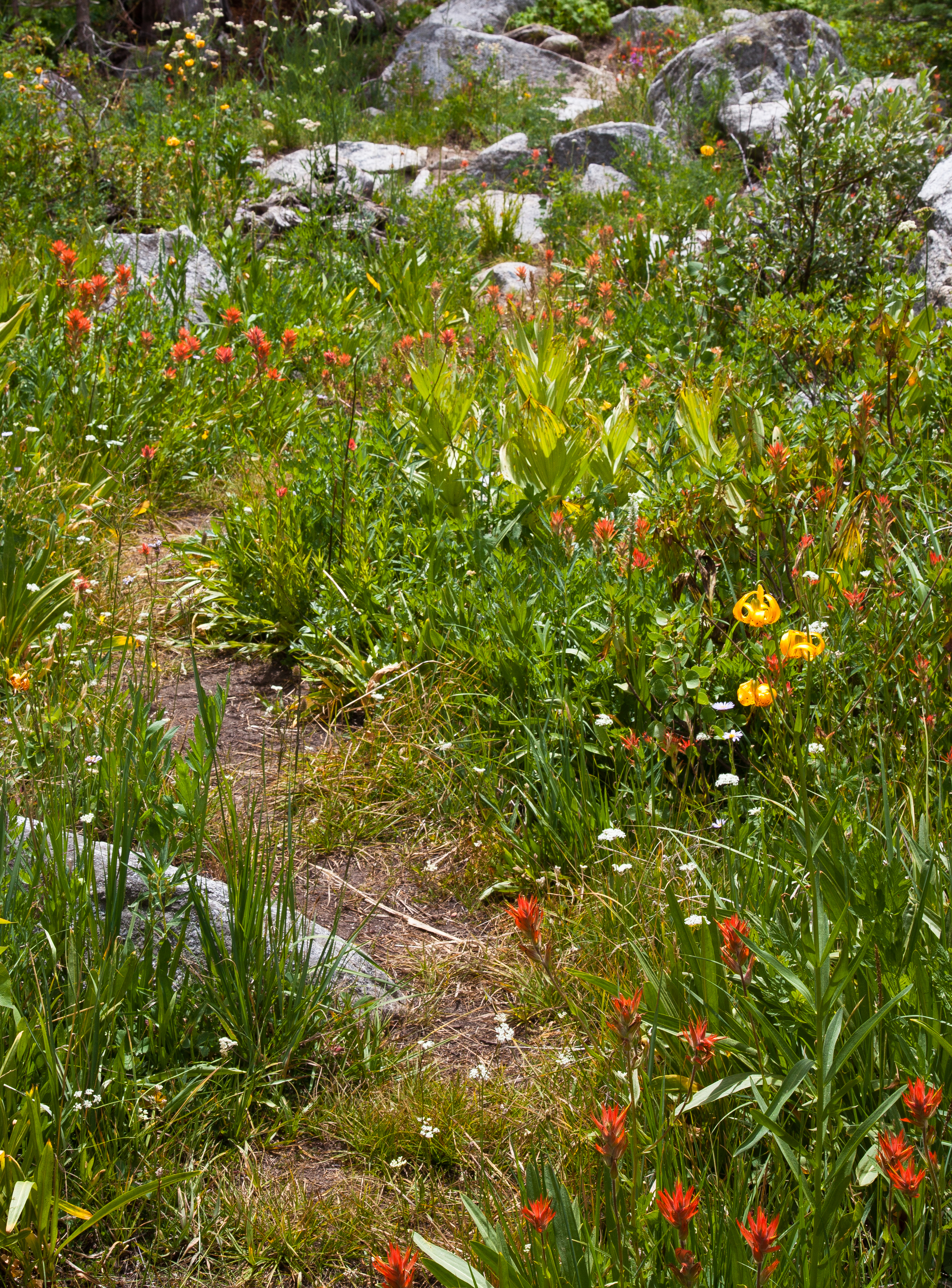
Wildflowers splashed color around the trail. A rainbow formed overhead. I looked around for Unicorns but I did not see any.


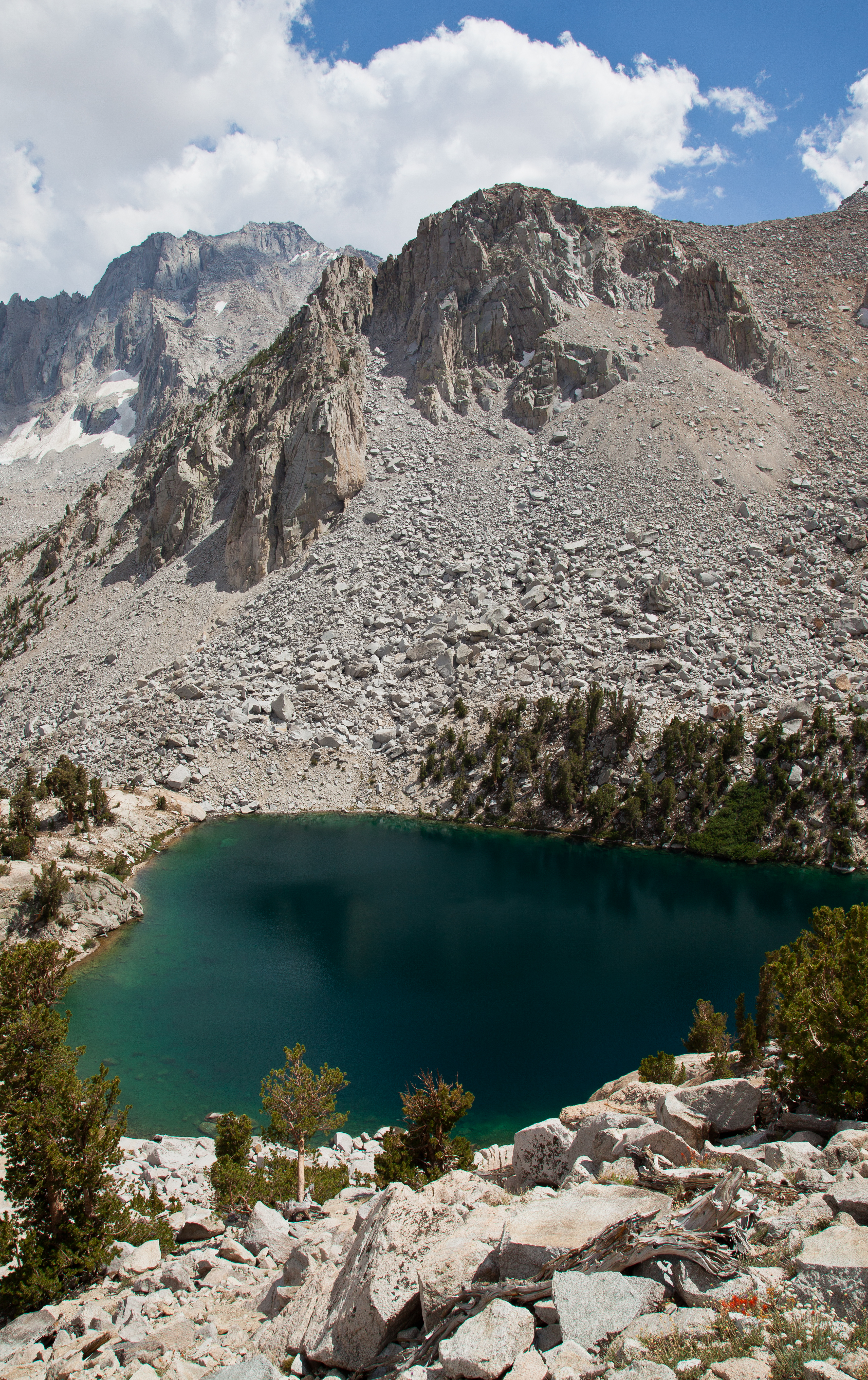
Colby Lake exceeded my expectations. It is perched below a beautiful steep ridge, and the opposite direction provides sweeping views of the Sierra. I had it all to myself. Exploring the lake revealed giant fish swimming around the lake shore. The water was also very deep and there were places where it looked like you could dive in directly from cliffs along the lake. Unfortunately, the weather took a turn towards the cold, otherwise I would have enjoyed a nice swim.
The cloudy skies were foreshadowing the potential for an incredible sunset, if the sun was able to break through on the horizon. I kept a close eye on the clouds on the horizon for any evidence that there might be an opening. It’s amazing how fast sunsets like this can pop up. A hint of orange tint started appearing in the clouds overhead and within a few minutes the sky was ablaze. I grabbed my camera gear and tried to get to work.
With a broken tripod, I was severely limited in my ability to set up shots. I figured out a way that I could hold my camera to the tripod as long as one hand was permanently fixed upon a lever. Framing a composition while making sure that my camera didn’t tragically fall into the lake was a very stressful and difficult task, but I somehow managed to pull it off.
The ridge line next to Colby Pass suddenly lit into a glorious red and the entire area was basking in the reflected glow. It was such an intense display of color I could barely believe it.

As quickly as the light show on ridge started, it ended. I was fortunate to even get a shot off during the couple of minutes that it was lit. Now, I turned my attention in the opposite direction towards the horizon, where I captured one of the most amazing color displays I’ve ever witnessed. The sky turned for a fiery orange, to a deep crimson, and then finally to a velvety purple before finally fading into twilight. I stood in awe and captured shot after shot of this amazing display of light.


Once it was all over, I let out a victorious cheer that echoed throughout the empty canyon and danced in jubilation from the amazing moment. I had witnessed the most beautiful sunset of my entire life, and it happened to be in an incredibly scenic Sierra canyon that I had all to myself. I had fulfilled my promise of an incredible day by leaps and bounds.
That night, winds howled and rain pattered on my tent until daybreak. After it had stopped for about 10 minutes, I emerged from my tent and considered my options. The weather seemed to be clearing up so I decided to go for it and started towards the pass.


The hike up the pass was steep and difficult, but it’s a short stretch and I was up top after a brief sustained effort.


Descending the canyon on the other side, I walked along the Kern-Kaweah river and headed towards the HST/Kern River.

At Gallats Lake I saw a cool horseshoe bend in the river, but outside of that I found this section of trail to be rather drab, at least in comparison to all the surrounding areas.


I had originally planned a side trip to Picket Creek Lake or Milestone Basin while I was in this area, but my altitude sickness hadn’t gotten much better and there were still many ominous looking clouds in the sky. I decided that going offtrail by myself with these factors was not the best idea, so at this point the goal of the trip was simply to get back to the car. It’s only 35 miles away with two 12,000 foot passes in between. No big deal right?
The rest of the day was spent making my way over to the John Muir Trail. First, I headed down to the Kern River valley, where I was back among the big trees and… bulbs?


Traversing over to the JMT, there is a fantastic view looking down the Kern River valley in the direction of the High Sierra Trail.

Once I hit the JMT, the peaceful solitude I had been enjoying for the past couple days immediately eroded. It was a little jarring to suddenly see so many people. The sun was quickly setting and the trail was in fairly thick woods. I began heading North, in hopes that I could find an opening that would allow me to do some sort of photography for sunset or sunrise. After a mile or so, I reached another group of campers and I asked if there was anywhere up the trail where I would be able to see sunset. A dazed kid in a poncho just gave me a blank stare and I realized that they might not be the most informed group of people to ask. The sun was about to set and I gave up on my hope to escape the trees and made camp.
The following morning I reached an opening in the forest after about 20 minutes and was immediately pissed off at the kid in the poncho.

Further along the trail, I reached Bighorn Plateau, which was one of the biggest highlights of the trip. I can’t wait to go back and spend some more time here.

This whole region is pretty incredible. It is essentially a giant plateau above the treeline, surrounded by striking peaks in every direction. The landscape feels epic, yet the trail is almost completely flat and the whole experience is incredibly relaxing. What’s even more incredible is how different this area is in comparison, to say, the Kern River valley which is only a few miles away. One of the things I love about the Sierra is the sheer variety and abundance of different types of natural displays of beauty.
The big obstacle for the day was Forrester Pass, which at 13,153 feet, stands as the second highest pass on the JMT behind Trail Crest on Mount Whitney. By the time the trail steepens to ascend to the pass, you are already well above 12,000 feet so the ascent is actually pretty easy if you are moving northbound. The landscape becomes increasingly sparse as you approach the pass.


Looking back…

This pass is another engineering marvel where the trail was literally carved out of a cliffside via dynamite. When I was at the bottom I couldn’t even tell where the trail went because I never would have believed the route that it takes.


Reaching the pass, I was back in Kings Canyon and was hitting the home stretch. I was only a few miles from the JMT/Bubbs Creek junction that I had hit a few days ago, and after that I was only a hop and a skip away from civilization. While my altitude sickness never vanished, it fortunately had not gotten any worse so I was feeling pretty decent as I began to descend down from the high mountain pass.


Instead of camp along the JMT again, I decided to explore a new area and get away from the crowds so I took a small detour into Center Basin. I found the basin to be completely empty and made camp between the first couple of lakes. It was a very calm and peaceful spot to end my week long sojourn. The afternoon light hit the center basin crags and I snapped off some photos of the last sunset of the trip.


As I headed out on the trail on the last day, I was already ordering a pizza in my mind. I blazed up the trail past Bullfrog and Kearsarge Lakes and was on the pass by noon.


I happily posed as a friendly hiker took my portrait. I thought the strap lines on my wrists were tan lines, but they disappeared after I showered :p. I was home 5 hours later enjoying a bounty of beer and food.

While a ton of stuff went wrong on this trip, it was a life changing experience for me. When I first reached Kearsarge Pass on day one, I felt a sense of uneasiness as I treaded down by myself into the deep wilderness. Upon exiting the wilderness over the same pass eight days later, I had conquered a difficult challenge and overcome a number of obstacles along the way. That feeling has carried with me and I now feel much more confident that I can follow through on whatever path my dreams take me on. I can’t wait to see where they take me next.

WOW. Very inspiring B. This has given me a lot to think about.
Dreams fulfilled bring so much sweetness into one’s life.
Thanks for sharing. That was a fantastic experience.
Very nice trip report. I just did Colby pass in the direction you did this last summer, and I disagree with your opinion that the stretch from Colby pass to junction meadow is not that appealing. I found gallants lake to be utterly amazing. Plus the hike down to rockslide lake and past picket guard is amazing, the waterfalls and scenery are stupid. Anyway, thanks for sharing, great trip report and congrats on completion of the trip!
Great TR. Did you mention what time of year this was? Late August?
Thanks! This trip was in mid July. 2012 was a very dry year so this turned out to be the perfect part of the season to go.
Reading your report and seeing your pictures nearly brings me to tears remembering a nearly identical 10 day trip in the same area back in 2008. Thanks for sharing… maybe I’ll do it again some day.
Thanks for sharing this wonderful trip. Your photos are beautiful and I enjoyed your commentary. Sorry you experienced altitude sickness. Have you considered trying diamox? Thanks again!
I don’t know why google returned me this blog in search about national park but am glad it did .
Very informational post, and i must say your pictures are amassing
Would it have been worth it to take along fishing equipment? Have done so in the past, but these days I like to try and keep the weight to a minimum? Did you talk to anyone that had done some fishing?
Yeah, it would have been worthwhile I think. I’m planning on adding that to my backcountry experience very soon. From the top of my head, I ran into a fisherman along the creek between East Lake and Lake Reflection, and he seemed to be having a lot of luck. I imagine the fishing near the Roaring River area is outstanding. I saw a ton of big fish in Colby Lake. I also think that the fishing along the upper Kern would be very good as well. Granted, most of this info is based on my assumptions more than experience, which I hope to rectify soon enough.
In 1971 when I was 20 and my Dad was 41, we hiked from Roads End up Bubbs Creek. He could have made it with a 60 pound pack to Center Basin in one day. 14 miles. I got altitude sickness and was very sore, but we made it on day 2. That afternoon he caught 3 of the largest rainbow trout I have ever seen in one of the upper Center Basin lakes. They were like salmon! He hiked and fished many years in that area. I have read that the Park service has tried to eliminate non-native species in the high lakes. So, if you return, I hope you do fish and post your experiences. The South side of the Forester Pass trail was scary to me then, and your pictures bring back many memories. You are a fantastic photographer and very good writer. I hope to send this post to my Dad who is 83, but very active. Unfortunately he lives in Oklahoma. Thanks for a very good job!
jb
Thank you for sharing that Jerry. It made my night.
Nicely done! Your pictures have me looking forward to this year’s stretch on the JMT through Kings Canyon. Too bad no dogs allowed…
No kidding! There are so many places in the Sierra that I want to see but am avoiding due to that law. I still haven’t done that section of the JMT through Kings. Fortunately there is plenty of dog friendly Sierra still available. We have some big trips planned for Callie this year.
awesome trip report/photos or this epic! id never heard/thought of Cloud Canyon and Colby Lake-i need to check it out now.
I’ve been trawling around on your blog for the past few days and its got me chomping at the bit to get out there. I’ve got a few local trips-just finished San B with a night at Limber Pine Bench- and have San G coming up-but i don’t get out to the Sierra til mid July. you’ve got me wanting/needing to find time to get out now 😉 nicely done. beautiful.
Hi! Great report, and fantastic photos! My wife are planning to backpack from Road’s End to Lake Reflection this coming weekend. The ranger told me that the trail from East Lake to Lake Reflection is not maintained. Is the trail well defined at least? How are the mosquitoes? I read on your blog that you had to cross a stream—do you know if there will be a stream crossing from Road’s End?
Thanks!
Hi Francis,
The trail between the two lakes is definitely not maintained. For the most part, it is still easy to follow, but there are a few spots where its easy to lose sight of it. Specifically, there is one boulder field that you have to cross. It’s still a pretty small valley and not that hard to find your way up it and back to the trail if you lose the trail for a bit.
The mosquitoes were not a problem when I was there, but this coming weekend I expect they will be much more of an issue. We are approaching their peak numbers for the season I would suspect.
The river crossing is right after you leave the Bubb’s Creek trail. You will definitely have to cross it from the Road’s End direction. It will probably be thigh deep. A few tips on that: mornings tend to be better than afternoons for crossings. If the crossing by the trail is too swift, I have read that there is a better crossing about 100 yards downstream.
Thanks for the prompt response! Helpful information! I just learned that my wife is feeling a bit ill…hopefully, she will feel better enough by the weekend. If not, we will have to delay our trip to a bit later this summer—which may actually be better, in terms of mosquitoes, that is 🙂
One final question…is that Banner Peak in the pic at the top of this page? From Thousand Islands Lake? It’s a beautiful shot!
The top picture is set to be random. There is a Banner Peak shot among the rotation so I’m sure that’s what you saw. Thanks!
Thanks! So my wife is indeed under the weather. We will have to do the hike sometime within the next couple of weeks.
Hi there again! Looks like we are headed down to KCNP early this coming week. May I ask what focal length did you use for the photo of Mt. Jordan from Lake Reflection? Did you use a full frame, or crop factor camera? If crop factor, 1.5 or 1.6? Finally, was the shot taken from the side of the lake where the trail ends, or did you have to go off trail to get that perspective? Would you mind sharing where on the lake did you take this photo from? It is a gorgeous shot, and I hope to come up with something close 🙂
I shoot full frame and that shot was at a wide angle. You’ll easily be able to recreate the perspective if that is your goal, but you should try to let the scene provide you your own inspiration.
Hi there! We just got back from the backpacking trip. Beautiful place! No clouds during sunset/sunrise, so I did not get any color in the sky, but that’s okay. The water crossing at Junction Meadow was thigh high, rather swift, and ice cold! But we got through just fine. Here are some of our pics in case you are interested:
https://plus.google.com/photos/101907599113421401654/albums/6033356824329041937?banner=pwa&authkey=CJiNh_bS64Oa_wE
Very nice Francis! Looks like a fantastic trip.
Nice photography and thanks for the posting. I have not finished since I stopped when the new background wood feature clouded out my ability to read your writings. Zooming in did not help.
Hi Jon. That is strange. The only thing I can think of is that the post is very large and contains a ton of large images, so it’s possible that your web browser ran out of memory and couldn’t display the entire post.
Based on your great pictures, I hiked to lake Reflection as my annual labor day hike. It is incredible. I am just sorry I did not spend a few days there. A ranger said the topography is very interesting heading toward Harrison Pass…next time. Thanks for posting this.
Calitrails … Thanks for the hours of effort you put into your on-line album, word-crafting your experience, and honestly relating the hardships and disappointments you faced. In the past three years our gang-of-mountain-lovers have hiked about 300 miles of the JMT, some sections twice. Year before last (2013) my brother broke his ankle on day 7 and hiked the 15 miles out to Road’s End (with a handful of pain pills). So we’ve been plotting how to return and capture the country you covered in your Solitude Loop … sounds perfect to fill in the missing gaps between Kearsarge and Whitney.
Many thanks for the photos, which show the trail to be rather obvious, though infrequently used at points. Your enthusiasm for the views from passes, up vallleys, into sunsets, and over lakes matches my wonder and joy at the magnificence which God created and gave us the bodies to enjoy.
You’re a great photographer who worked hard for right light, right angle, right focus. I’ve been hiking the High Sierras for over 50 years and am always and continually aweswtruck at the beauty, which Backpacker Magazine calls “the most beautiful trail.” Thanks for the report and photos!
Thanks for the wonderful comment Hollis.
Several of us from Georgia and Alabama are seriously planning to follow your 88-mile “solitude” trek. We’ve hiked 300 miles of the JMT, some sections twice, in the past three years, and would like to tackle the “solitude” loop into Kings Canyon. So, we have a few questions, if you’ve time to respond. 1) Which ‘geo’ maps did you use for your trek? I can find your route from Onion Valley to Lake Reflection, and then lose your trail until you approach Forester Pass above Tyndale Creek. 2) Are the trails and routes well marked, or are some of the trails faint/unmarked/disrepair? 3) Could you send me a step-by-step landmark sequence you followed, so we can trace your route on a map? 4) Finally, do you have an approx idea of total ascent/descent feet? I’ve been hiking, off an on, the High Sierras for 40 years and always thrilled at scenic vistas … keeps me up at night, and affords us “mountain crazies” wonderful hours of planning, buying gear, dreaming about sleeping out in the wilds. Many thanks for your advice and map directions! Hollis
Hollis, I’ll do my best to answer your questions here. Send me an email at brian@calitrails.com if you want to take the discussion further.
1) I use Tom Harrison Maps. If you get the Kings Canyon/Sequoia Map, you should see this entire route on there. It’s very zoomed out though so it lacks topo detail. You can bring the Mt Whitney High Country and Kings Canyon High Country Tom Harrison Maps to get the whole route with some additional detail. Caltopo.com is a great resource as well.
2) The route and trails are very well marked. The only section that isn’t is the stretch of trail between East Lake and Lake Reflection. This is more of a use trail. That stretch up to Lake Reflection was a side trip off of the Circle Loop that added an additional 8 miles and 2,000 feet of elevation gain, so keep that in mind.
3) I have a map linked on my trip report that has my route marked with a red line. That should be enough info for you to retrace my route.
4) I think I calculated it when I was planning the trip, but that was 3 years ago now. I’d estimate somewhere between 15,000 to 20,000 feet of elevation gain/loss over the route I did.
My last note would be that this route is loop is probably easier to start out of Roads End in Kings Canyon. The main reason I chose to start on the east side and go over Kearsarge is because the drive was much shorter for me and the permitting process was easier as well.
Awesome hike, awesome TR.
Hey Calitrails! Where do you go to reserve permits for this trail? I’m having a difficult time tracking down the proper permit system. I’m looking to do it in early June; how do you think the conditions will waver? We’ve had a really dry winter, so I’m not too worried about the snow packs.
If you follow the same route that I did, you’ll want a permit for Kearsarge Pass which is obtained through Inyo NF on recreation.gov.
The shorter and probably preferable route is to start at Road’s End in Kings Canyon National Park. They have their own permitting system.
A permit through Kearsarge Pass is our choice, seven of us hiking out in mid-July, following the full “Cirque” route. Kearsarge is a high pass on day 1, but it’s absolutely spectacular, one of the most photogenic in the entire JMT (which we finished last summer). Permits must be picked up in Lone Pine Ranger Station … ranger says this is an unusually busy summer due to the movie “Wild” publicity about the JMT. Walk-ins may be available, so give the ranger station a call. Rooms, round-trip shuttles, and car parking available at Mt. Williamson Motel in Independence. Good luck!
was it mandatory to be equipped with a bear canister?.if so,what brand and size did you use. i’m mirroring your hike this summer. thank you,john
Yes, they are required. I used a large Bear Vault.
I’ve hiked 100 miles per summer in the JMT and High Sierras … the BV 500 (large) will carry 6, maybe 7 days of food at 3100 calories per day. And they are grand to sit on vs. the hard rocks.
David,
Seven of us did the Circle of Solitude last July. Stunning country. Colby Pass. Kearsarge Pass (twice). Camping at incredible Kearsarge Lakes (twice). Forrester Pass. Magnificent views, roaring streams, and not very many people … one of my lifetime marvelous treks. This summer a few of us from Alabama and Georgia are doing the High Sierra Trail … but I’d do the Cirque again in a heartbeat. Rae Lakes are beautiful … did them three years ago … but I’d recommend the Cirque first and foremost.
Very impressive and informative report, much appreciate it. My wife and I are inspired and we are going to follow your foot step, although we will start from NW corner Road end toward JMT and then return by Colby pass and Avalanche Pass, about 90 miles in total (including Mt Whitney trail).
I just wonder how was your food pack for 8 days. What do you think about hiking for 10 days without food resupply? The maximum load of food I ever had is for 7 days.
Another question is do you keep GPS tracking? Or the trails are well marked (especially on Colby/Avalanche) and no need for GPS track? It will be our first time hiking in Kings/Sequoia parks
Much enjoying reading your report
Yuan
I probably carried about 10 pounds of food. I think 10 days without resupply is totally doable but you’ll need a big bear canister or more than one. I don’t keep GPS tracking.
I burn around 5000+ calories per day, and my diet is 3,100 calories, so I’m withdrawing about 2000 calories (1/2 lb.) of body fat, glycogen energy, or muscle per day. In 8 weeks and 600 miles of hiking in the High Sierras in the past 5 years I found I typically lost 5 lbs. of solid body weight.
I eat 3,100 calories a day to keep up energy, avoid “bonking”, and to maintain protein and muscle recovery. Those 3,100 calories weigh 1.6 lbs/day. And I typically can only get 6.5 days into the BV500 bear canister, the largest available on the market, and nicely fitting into the bottom of my 58-liter Osprey. So, it’s a dicey balance between pack weight, size of bear canister, sufficient energy not to “bonk,” protein to re-build muscles, and how many days on the trail.
I have personally seen the wretched condition of men in their 40’s-50’s-60’s on these endurance hikes who absolutely wiped out (“bonked”), lost all appetite (more bonking), or threw up several times a day in altitudes above 8,000 feet because of insufficient or wrong types of food. Eating right is not an option … it’s a necessity to enjoy these great treks.
I’ve had the good fortune to hike the Cirque of Solitude last year, and this year to hike the High Sierra Trail from Sequoia to the JMT and out Cottonwood Lakes, a total of 150 in two treks. The Cirque is incredible. Kearsarge, Colby, and Forrester passes are breathtaking once in a lifetime dream climbs. The many lakes with looming mountains behind are world class. REgarding food … we can’t get more than 6.5 days in a BV500 bear vault. So our 8 day trips require us to move some of the food outside the canister for about two days. Usually we eat Mountain House, which is air/smell tight. We soap-wash the packages to remove all outside scent, then encase them in two layers of 2.5-gallon zip-lock bags. And just as fast as we can we get all scented items into the BV.
In the past five years I’ve taken five 80-150 mile treks through the Sierras. Seen mama and 2 cubs on two occasions. Only one other black bear. So 3 sightings in five years and 8 weeks in the mountains.
Best wishes to you and your wife to enjoy this incredible country … God’s creation which reflects some of His glory. My heart swells whenever I’m in the altitudes. Good luck!
Thanks for these great trail reports and photos!
Your Circle of Solitude trip reminds me of a week-long transit of the Bob Marshall Wilderness 45 years ago, when I was 23 – only only in the Sierra there are no longer any grizzlies…
I hiked with my dog last July to Bishop Pass and at the summit wound up hoping I could meet someone who could take him back down to the Owens Valley for a few days so I could continue legally into the park – but even if that momentary fantasy could have come to pass, I would have been sad to hike on without my great trail buddy (my other great trail buddy, my wife, had to fly back home to Wisconsin to work for a living, of all things, after a week hiking with me and our dog in the Hoover and Ansel Adams wilderness areas).
I have been looking at maps showing the great concentration of trout-supporting lakes in Kings Canyon and hope to visit a bunch of them this coming summer. Thanks for your inspiration!
Great post. Your sunset pictures are stunning. My boyfriend and I just finished a very similar route- it was amazing! The “bulbs” are snow flowers 🙂
I love the photo with the Sky Pilot! It is my dream to see it one day. Thank you so much for the inspiration!
great trip report